While exciting in its own right, Kate’s pregnancy put a damper on any ambitions we had for 2017 to be a big race year for Strong Machine AR. Her due date of July 23 effectively ruled her out for the entire season, and Cliff planned to scale back his racing in solidarity (also due to a broken collarbone suffered in June).
However, as one of only three adventure races in New England in 2017, and run by our good friends (and RD mentors) at the Green Mountain Adventure Racing Association, Cliff wanted to do his best to make it to the Bitter Pill. Planned for August 12 at the Sugarbush ski resort in Vermont, Cliff thought the timing would work out to get the baby out, settle Kate in, and hustle out to Vermont for a quick 12 hours of racing. So Cliff recruited Vermont local Chris Sussman and ITERA vet Claire Poulin, who happened to be hiking the Long Trail, and got the team registered. Of course, there’s an expression about “best laid plans” that Cliff probably should have given more credence to…
Kate’s due date rolled by with no sign of a baby wanting to emerge. A full 15 days after his due date, Wilder White arrived on August 7, happy and healthy and completely oblivious to the trouble he had caused for his poor father. But Kate, being the amazing person that she is, gave Cliff the go-ahead to race.
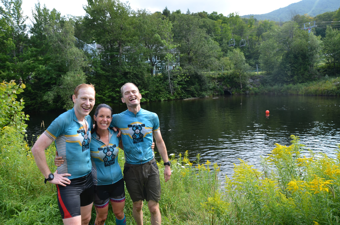
Cliff met up with Chris and Claire for the gear check at around 8 p.m. on Friday, and after passing inspection and getting our photo taken (donning our nice uniforms, which were exchanged for our crappy old ones for the race), we headed to dinner at the Mad River Inn, then set up camp at near the Sugarbush base lodge. Knowing that GMARA is famous for its short turnaround time between race briefing and race start, we left nothing to do for the morning of the race besides cramming calories into our faces and marking up our maps. We settled into our tents (actually, Claire slept in her rental car, which she had driven up from Killington, where she had jumped off the LT), and were about to pass out when a huge rain storm hit us, sending us scrambling to close the vestibules and car windows. After settling back in, we had about 1.5 hours of "sleep" - Cliff, at least, was too worried about being in charge of navigational duties instead of regular navigator Kate - before our alarm went off at 3:40 a.m.
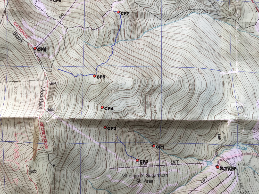
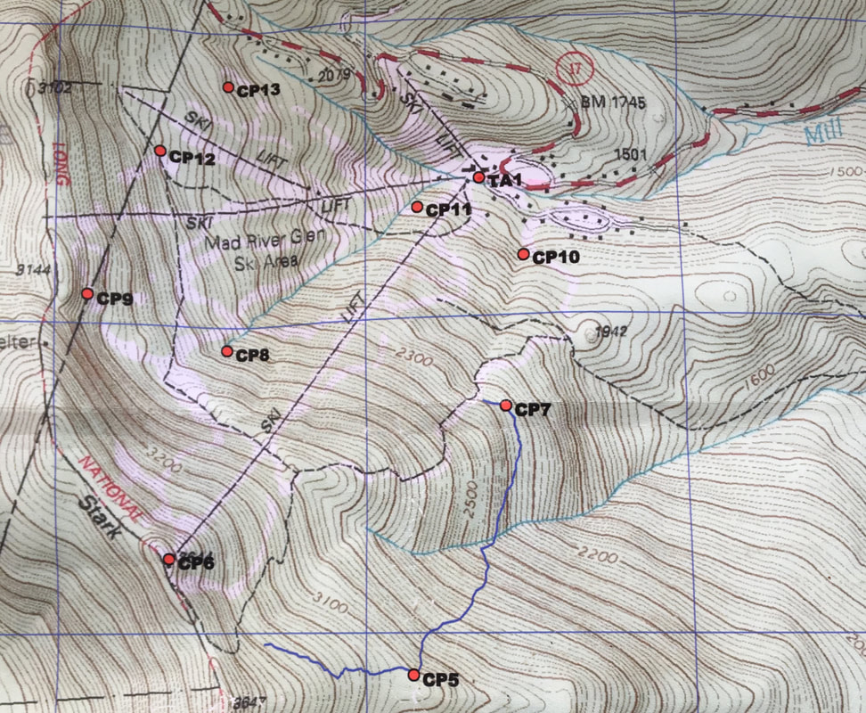
The race briefing began at 4:30 a.m., and we had about 15 minutes with the maps before we were being called to line up at the start, which was at Sugarbush’s Mt. Ellen area. Scrambling to make sense of the course, Cliff read through the race directions, which showed a trek with 5 CPs leading from Sugarbush up and over the top of a ridge (featuring a 2,000-vertical-foot gain) into Mad River Glen. Starting from the top of Mad River Glen, there followed a 7-CP orienteering section, then a bike to the south side of Sugarbush to a 6-point mountain bike (with one bonus CP), a return trip to the Mt. Ellen area of Sugarbush and final climb to retrieve two finals CPs (with three more bonus CPs for the speedsters). Overall, the course looked like it had a lot of elevation gain, but not too much mileage. If all went well with the nav, Cliff thought it was clearable, and so we decided to be more aggressive with our strategy, with the knowledge that we might have to scale back our ambitions later in the race.
With our heads still groggy from waking up and the enveloping pre-dawn darkness not helping, the race started and we began trudging up a steep ski trail. We chatted for a bit with Kit Vreeland, New England racer extraordinaire, and after about 600 vertical feet of climbing – using Chris’ altimeter to judge our location – we veered off into the woods to find CP 1, which was on a stream, according to its clue. We down-climbed into the reentrant, where we could clearly hear a stream, but we lost too much elevation and had to climb back up the steep streambank to find the CP. But we had moved fast and were still ahead of the main pack of racers, which we could see behind us in a conga line of headlights.
Surprised to find ourselves alone already, we made our way efficiently to CP 2, which was on the side of a major ski trail, where we saw a few other teams and RD Chris Yager. He suggested we take a look out at the view, and we turned around to witness a beautiful patchwork of clouds blanketing the surrounding mountains in a hazy gray light. It was hard to peel our eyes away from the view, but we knew we had to keep moving to stay ahead of the pursuing horde. A jeep trail led most of the way from CP 2 to CP 3, winding its steadily way up the mountain through tall grass and the occasional swampy puddle. We found CP 3 with a couple of all-male teams, then took a bearing to CP 4, which was located at a “junction.” We assumed this meant reentrant junction, but we also were on the lookout for a trail junction, just in case. Attempting to be helpful, Claire also suggested we watch out for a conjunction junction.
After a fair bit of uphill hiking, Chris’ altimeter alerted us that we had gone too high up the mountain, and we backtracked a bit to find a stream that we followed until it met another stream – a junction we were relieved to see happened to be the location of the CP. For the first of what was going to be a total of three times in the race, Cliff had taken the team too far to the north, failing to take declination into account in his bearing shot. Not learning from his mistake, he did the same thing for CP 5, and we quickly ended up all alone in the thickest bushwhacking any of us had ever done…a morass of young evergreens that slowed our progress to a crawl. Making matters worse was the fact that the trees were soaking wet due to the storm that had rolled through the night before. We had moments where we thought we might have to turn back, but just as we were seriously considering it, we popped out on the trail leading to CP 5. On our way down to pick up the point, we passed a couple of teams, who looked at our soaked-through uniforms covered in pine needles and wondered out loud what swamp we had crawled out of.
.After punching CP 5, race rules gave us a choice of tackling the next eight CPs in any order, and we only had to get five of them to stay on the full course. But given how well we were doing on time, we decided to at least start out with the goal of getting all of them. We headed uphill on the marked trail to the top of Mad River Glen, where we easily found CP 6 at the warming hut near the top of the ski lift. We then made our way to CP 9, then downhill to CP 8, and then across the mountain to CP 12, and – perhaps feeling cocky after so much easy success – shot a bearing to CP 13 and started off at a jog. The clue was “base of cliff” and when we ran into a set of cliffs, we began looking around in earnest. When we couldn’t find the point, we continued on until we hit another set of cliffs – again, no luck finding the point. We continued on this way until hitting a road – a clear backstop and sign we had gone too far north. We turned around, had Chris zero us into the correct elevation, and wandered south in search of the CP. We actually walked past it at first, but another friendly team told us we missed it and we backtracked to punch. Wasted about 30 minutes here.
From CP 13, we considered traversing across the mountain to CP 7, but decided instead to descend to punch CP 11, which we found by a gorgeous waterfall, and then CP 10, located near a treacherously slippery wooden bridge. Before anyone could hesitate, we started the 500-vertical-foot climb up to CP 7, finding it without major difficulty – other than the very steep climb itself.
At this point, it was 9:40 a.m., and we were feeling pretty good about clearing the o-section well before the RDs’ recommended end time of noon. We headed back to the base area at a run, aiming for a quick transition. There were a number of teams already in transition so it was hard to tell what place we were in. Having seen other teams at virtually every CP we had visited, we assumed we were middle of the pack. Even with a water refill and a bacon/Goruka bar snack, we managed to get in and out in 13 minutes. We headed out down a perfect road – downhill and paved – toward the Lincoln Peak area of Sugarbush.
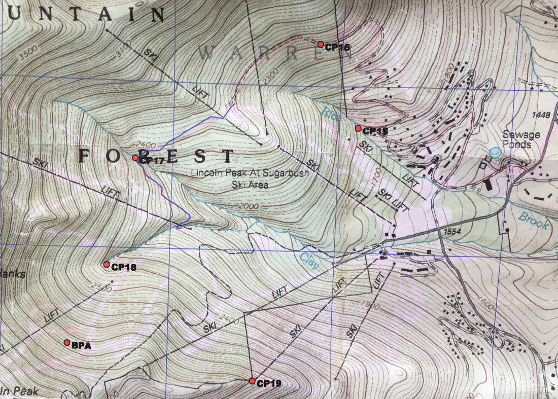
The ride went smoothly, as we nailed a right turn onto a road leading to Tucker Hill Ski Center, which we saw had recently become Tucker Hill Pig Farm. CP 14 was located on a trail nearby, and we hit it and continued on. We reached the ski hill about 20 minutes later, and were briefly confused as some teams headed for the base of the ski area. However, from the map, it appeared as if we needed to stay north of the ski resort and use an access road to climb up to CPs 15 and 16. We took three or four minutes to make sure, then headed away from the ski resort and uphill on a series of switchbacks. Near CP 15, we ran into another team, and we rode with them for a bit before stopping to punch. We talked with them and found out one of them worked at Sugarbush and knew every inch of the mountain. He gave us detailed directions to several of the CPs that looked tricky on the map, and we thanked him profusely for his help.
We pulled away on the ride up to CP 16, and hit a steep hill right before the point that slowed us to a crawling push. At the top, we were relieved to find the trail relatively flat and rideable, and followed it to CP 17, at a bridge. The trail continued to the base of a ski lift, which was our cue to make a right turn and head uphill. CP 18 was located in a stream/reentrant, and at what we thought was the correct elevation, we headed off the trail and into the woods to grab it. However, the steep descent to the stream caused us to lose more elevation than we expected, and we ended up having to walk a fair bit up the stream to find the CP – the second time we had to do that in the race. It would happen again on CP 21. This bobble cost us another 20 minutes or so, but had the positive side effect of allowing us to cool down in the refreshing mountain stream. We gathered handfuls of the cool water and poured it over our heads, and the feeling of the cold sting rush down our backs was invigorating. This was key as we turned back uphill on a grassy ski trail scorched by the sun. The slope was very steep and our progress was slow as we gained 550 vertical feet on our way to pick up Bonus Point A. At the correct elevation, we dropped our bikes and ran in to find the point on a MTB trail back in the woods a bit.
We pulled away on the ride up to CP 16, and hit a steep hill right before the point that slowed us to a crawling push. At the top, we were relieved to find the trail relatively flat and rideable, and followed it to CP 17, at a bridge. The trail continued to the base of a ski lift, which was our cue to make a right turn and head uphill. CP 18 was located in a stream/reentrant, and at what we thought was the correct elevation, we headed off the trail and into the woods to grab it. However, the steep descent to the stream caused us to lose more elevation than we expected, and we ended up having to walk a fair bit up the stream to find the CP – the second time we had to do that in the race. It would happen again on CP 21. This bobble cost us another 20 minutes or so, but had the positive side effect of allowing us to cool down in the refreshing mountain stream. We gathered handfuls of the cool water and poured it over our heads, and the feeling of the cold sting rush down our backs was invigorating. This was key as we turned back uphill on a grassy ski trail scorched by the sun. The slope was very steep and our progress was slow as we gained 550 vertical feet on our way to pick up Bonus Point A. At the correct elevation, we dropped our bikes and ran in to find the point on a MTB trail back in the woods a bit.
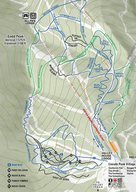
Returning to our bikes, we had another 100 vertical feet of climbing to do to hit the correct bike trail leading to CP 19. Unfortunately, we accidentally ended up on the wrong trail, and descended 200 or so vertical feet before realizing our mistake. But Cliff found a lower path that led to CP 19, and with a little creative hike-a-bike, we were on it. Then it was a choice of which downhill trail to take to the bottom. With Cliff’s broken collarbone still mending and Claire no big fan of steep descents, we opted for a blue trail called Snowball. It was still plenty steep and we all ended up walking parts of it. We watched as another team that included Maine Summer AR vet Baxter Miatke (great to see him out with friends after making MSAR his second ever AR last year) bombed down the trail, getting high up on the banked turns and dropping down some rocky cliffs. It looked like amazing fun. Hopefully these trails get included in next year’s race so we can give them another go.
At the bottom of the run, we retraced our steps to German Flats Road, the access road the start/finish area. It took us about 20 minutes to arrive, and when we did, RD Chris greeted us with a creative gear check. We had to pick a number between one and 10, with each number corresponding to a piece of gear that we then had to prove we were carrying. It added some fun to a task that otherwise can be an annoying disruption of a race’s rhythm…hope Chris doesn’t mind if we steal this for MSAR!
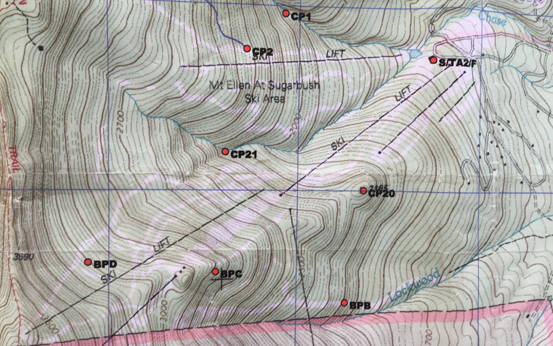
We had two more points to get (and potentially three more bonus points, if we had time), and it was 2:45 p.m., meaning we had more than two hours. Before we set out on our last climb of the day, we were told by Chris that there was a secret bonus point – a swim in a pond nearby the TA. Excited to know we’d get a free bath before our drive home, we opted to save this for our return to the TA.
CP 20 was located on a knoll directly above what looked to be a ski lift on the map. However, by the time we reached what should have been the top of the lift, all we saw was a lift terminal – and no actual chairlift. Still, Cliff was positive we were in the right place, and 10 minutes of bushwhacking uphill later, we found the CP in a beautiful mossy alcove. From there, we decided we should play it safe and not go for any more bonus points, and so we sidehilled it north heading to CP 21. Halfway to the CP, we popped out at the top of another ski lift, and were suddenly surrounded by about 10 other teams, apparently searching for CP 20. They had gotten their ski lifts mixed up on the map. We stopped to help a couple of teams orient themselves and pointed them south toward CP 20, and then continued on to the stream where we knew we would find CP 21. Once again, Cliff had the team duck in too early, and we ended up doing a long hike up the stream, which despite taking longer, actually was very refreshing, as the day was getting hot.
After about 10 minutes of upstream hiking (coasteering?), we found the final flag, then traversed out of the woods and onto the ski trail. We then pointed our toes downhill and made a break for the TA and the swimming pond. By the time we reached the pond, we were at maximum sweat and stink, and we didn’t hesitate in jumping right in the pond, led by Claire, who got to the buoy in the center of the pond and rang the attached cowbell, signaling to the TA that we had gotten the “CP.” It was about this time that we realized just how cold the water was, as it was running directly off the mountain and apparently not warming up a bit on its way down. We headed for shore and as we emerged from the water, our bodies started stinging from the intense cold. It felt delicious.
After about 10 minutes of upstream hiking (coasteering?), we found the final flag, then traversed out of the woods and onto the ski trail. We then pointed our toes downhill and made a break for the TA and the swimming pond. By the time we reached the pond, we were at maximum sweat and stink, and we didn’t hesitate in jumping right in the pond, led by Claire, who got to the buoy in the center of the pond and rang the attached cowbell, signaling to the TA that we had gotten the “CP.” It was about this time that we realized just how cold the water was, as it was running directly off the mountain and apparently not warming up a bit on its way down. We headed for shore and as we emerged from the water, our bodies started stinging from the intense cold. It felt delicious.
We walked to the TA and officially finished at 4:22 p.m. With the amount of time remaining on the board, we probably had time to get at least one additional bonus point, but it was nice to have a stress-free finish, and looking at the results posted a few days after the race, we would have needed to get al three bonus points to even have a chance to improve our placing.
Even though we didn’t know the results, we pretty much knew that we had finished in third place in the co-ed premier division, as Chafing the Dream and Rugged Road are in a different league from us speed-wise. Our friends Jeff Woods, Dave Lamb and Joe Brautigam from Untamed New England took second overall, and a two-person male team took fourth, leaving us in fifth out of 35 teams. Frankly, we were a bit surprised at the result, since we really hadn’t been pushing the pace too much. More than the 5th place overall, we were happy to have achieved our two primary goals for the race: to qualify for USARA nationals (top four co-ed premier teams did so), and to experience another GMARA race and support the AR scene in New England.
Huge thanks to Chris and Shawn of GMARA for being flexible about our registration (babies that arrive 15 days late tend to cause planning difficulties), and for putting together another fantastically fun and beautiful course. Looking forward to once again representing New England at USARA Nationals in September!

